
OK, here I am at last at the Marree Telecentre, in the middle of the Aussie desert with a bit... no, a LOT more to tell and show you from our fabulous and very chilly trip outback! Youo all know what a chatterbox I am... well, I write the same way, so be warned - there is a lot to read! I hope to upload all the photos I've chosen for each day and once again, they'll probably be at the top of the post first and then the test to follow... it is just easier than fiddling around with them trying to put them in the right places! Alright, here goes... photos first then text next! Enjoy and thank you for following our wonderful roadtrip.


Oops!!! NOT oilfields... these are COAL fields! ;o)


Cobar to Silverton
After checking the car and roof rack, we departed Cobar for the long haul to Historic Silverton, 24 kms from Broken Hill – almost 500kms! It was a very windy & cold morning today so it was nice to get into the car and head off along the very straight bitumen highway. As before, there are hundreds of feral goats in this area – we saw huge flocks of them all along the highway along with a few emu’s. Brown kites and Wedgetail Eagles are now being seen more frequently too. The eagles are magnificent birds! The countryside is increasingly sparse of trees, mostly saltbush following the flooding of the recent months. This area is normally very dry and barren, but with the recent rains and floods, there is new life everywhere. The highway is very straight and you can see for 100’s kms into the distance!
We stopped in historic Wilcannia briefly to have a bit of lunch by The Darling River – wonderful sight to see so much water in the river. This is a very historic town – it was originally a bustling river port in the late 1880’s. It still has many beautiful old sandstone buildings everywhere, but sadly the town is in serious decline. There are now numerous Indigenous families living in the town and unfortunately, there is little respect for the old buildings, many of which are now covered in graffiti. We were even discreetly warned by a local prison officer NOT to leave the car unattended and also not to walk around town as we would be pestered for money or cigarettes! Better to take the car, park it wherever we were going to be sightseeing in town, walk into the building and then get back in the car and go to the next spot! Driving past the beautiful old courthouse, it was clear from the large crowd waiting outside, that it was going be a busy day in court! After lunch we hit the road again with the countryside now even more barren, apart from a little oasis near the Topar Roadhouse, where large lakes still covered the ground following the floods of January and February. What a sight it was, all that water in the vast arid countryside!
As we neared Broken Hill about mid afternoon (clocks turned back half an hour due to different time zones!), you could see the huge hills of tailings from the mine that sits right in the city!! The main deposits mined here are silver, copper and zinc. It is a large busy city with many lovely old turn of the century buildings, including the old hotel used in the movie “Priscilla, Queen of The Desert”! We continued on to Silverton, about 24 kms further NW of Broken Hill and booked into the lovely Penrose Park – a vast outback caravan park with many animals and birds, both wild and caged. Fortunately we found a grassy spot to set up camp and next to a nice couple from Melbourne. As we were staying here for 2 days, we could relax a bit – enjoying an early morning cup of tea under the stars and watching a fantastic sunrise, took a long walk around the park and later in the day we went into Silverton to see The Old Gaol & Museum – fascinating history and SO much to see. Then it was on to the famous Silverton Pub for a couple of drinks – it was now 21C! Rather warm for a winters day! This is a great pub with hundreds of photos of the many celebrities, movie sets, numerous famous commercials etc that has taken place here. Movies like A Town Like Alice, Razor Back, The Cattle King & most well known, Mad Max 2! The big old black Falcon from the MM movie is still parked out the front of the pub! A rather nice way to end the day, before heading back to the camp to make a Beef Burgundy Casserole for dinner. By now the gusty winds had dropped off completely and it was a beautifully still warm evening, gorgeous sunset colours... but some ominous grey storm clouds developing in the distance!
Daily Trip Statistics
Day 5
Silverton to “Glenroy Estate’, Carrieton, South Australia
Daily Trip Statistics
TOTAL DISTANCE: 307km
MIN. ALTITUDE: 170m
MAX. ALTITUDE: 450m
TOTAL TIME: 4hrs 30 mins
DRIVING TIME: 3hrs 35mins
STOP TIME: 55mins
AVERAGE SPEED: 64Kmh
AV ERAGE DRIVING SPEED: 82Kmh
MAX. DRIVING SPEED: 128Kmh
Orroroo to Merna Mora Station
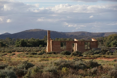
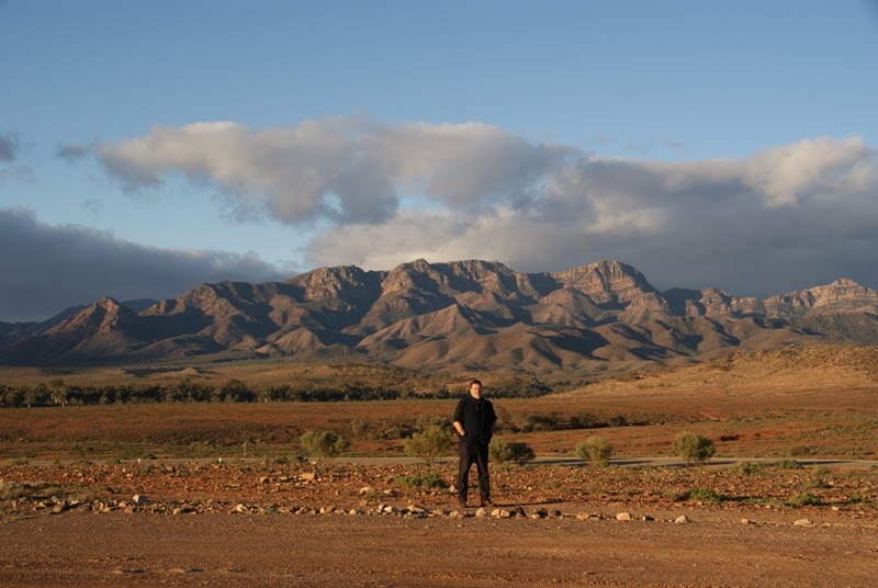
We headed off to see a few sights around Orroroo – The Giant 500 year old River Red Gum Tree and The Water Tank Lookout – before making our way out to Glenroy Estate covering some 22,000 acres of which about 2000 acres is Old Man Saltbush grown for as feed for the sheep. Absolutely beautiful countryside, scattered with numerous old ruins of times gone by. I also took numerous photos along the way and of the homestead for Fleur and her next novel, Purple Roads! After a lovely couple of hours with the Parnell’s we decided to push on to make up for lost time. This time, heading to Hawker and staying at Merna Mora Station just north of Hawker. We had an isolated campsite on the other side of the wide creek-bed lined with huge river redgums, no-one else around and with magnificent views of The Flinders Ranges and Wilpena Pound! Awesome! What a special night – full moon with the partial eclipse, not a breath of wind and so still... no sounds apart from our campfire crackling away as we cooked our dinner over the fire. I even made us some damper and cooked it on the fire! We both had the best night’s sleep here!
Daily Trip Statistics
TOTAL DISTANCE: 124km
MIN. ALTITUDE: 206m
MAX. ALTITUDE: 500m
TOTAL TIME: 2hrs 08 mins
DRIVING TIME: 1hr 27mins
STOP TIME: 40mins
AVERAGE SPEED: 57Kmh
AV ERAGE DRIVING SPEED: 82Kmh
MAX. DRIVING SPEED: 131Kmh
Merna Mora Station to Marree
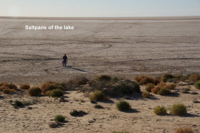
After having a fabulous hot shower at Merna Mora we departed for Marree with the awesome sight of the Flinders and Wilpena Pound on our right along the road. We took a little detour to Brachyna Gorge Geological trail, which was well worth it for the excellent views and information on the area. Back onto the highway, passing through Leigh Creek with its huge open cut coal mines and Lyndhurst which is the turn off to the Streczlecki Track to Innamincka and Moomba Gas and Oil Fields. Most of the road is sealed bitumen with just the last 60kms or so to Marree being unsealed, but reasonably good condition. We have booked into the very neat Drovers Rest Caravan Park here in Marree – this really IS desert country! Flat and vast with the most amazing sunset colours I’ve ever seen in a totally cloudless clear sky! WOW! We’ve been for a little drive into town for a drink at the local Marree Pub and a chat to a few of the locals and other visitors. Very nice way to end the day! Andrew has just made us a nice little Sunday roast – Pousson and vegetables! Once again, it is a very chilly night here in the Aussie desert so the goosedown sleeping bags beckon us!! Another day of exploring tomorrow!
Daily Trip Statistics
TOTAL DISTANCE: 259km
MIN. ALTITUDE: 56m
MAX. ALTITUDE: 300m
TOTAL TIME: 3hrs 54mins
DRIVING TIME: 2hrs 50mins
STOP TIME: 1hr 04mins
AVERAGE SPEED: 64Kmh
AV ERAGE DRIVING SPEED: 90Kmh
MAX. DRIVING SPEED: 139Kmh


Oops!!! NOT oilfields... these are COAL fields! ;o)


Days 3 to 7
Cobar to Silverton
After checking the car and roof rack, we departed Cobar for the long haul to Historic Silverton, 24 kms from Broken Hill – almost 500kms! It was a very windy & cold morning today so it was nice to get into the car and head off along the very straight bitumen highway. As before, there are hundreds of feral goats in this area – we saw huge flocks of them all along the highway along with a few emu’s. Brown kites and Wedgetail Eagles are now being seen more frequently too. The eagles are magnificent birds! The countryside is increasingly sparse of trees, mostly saltbush following the flooding of the recent months. This area is normally very dry and barren, but with the recent rains and floods, there is new life everywhere. The highway is very straight and you can see for 100’s kms into the distance!
We stopped in historic Wilcannia briefly to have a bit of lunch by The Darling River – wonderful sight to see so much water in the river. This is a very historic town – it was originally a bustling river port in the late 1880’s. It still has many beautiful old sandstone buildings everywhere, but sadly the town is in serious decline. There are now numerous Indigenous families living in the town and unfortunately, there is little respect for the old buildings, many of which are now covered in graffiti. We were even discreetly warned by a local prison officer NOT to leave the car unattended and also not to walk around town as we would be pestered for money or cigarettes! Better to take the car, park it wherever we were going to be sightseeing in town, walk into the building and then get back in the car and go to the next spot! Driving past the beautiful old courthouse, it was clear from the large crowd waiting outside, that it was going be a busy day in court! After lunch we hit the road again with the countryside now even more barren, apart from a little oasis near the Topar Roadhouse, where large lakes still covered the ground following the floods of January and February. What a sight it was, all that water in the vast arid countryside!
As we neared Broken Hill about mid afternoon (clocks turned back half an hour due to different time zones!), you could see the huge hills of tailings from the mine that sits right in the city!! The main deposits mined here are silver, copper and zinc. It is a large busy city with many lovely old turn of the century buildings, including the old hotel used in the movie “Priscilla, Queen of The Desert”! We continued on to Silverton, about 24 kms further NW of Broken Hill and booked into the lovely Penrose Park – a vast outback caravan park with many animals and birds, both wild and caged. Fortunately we found a grassy spot to set up camp and next to a nice couple from Melbourne. As we were staying here for 2 days, we could relax a bit – enjoying an early morning cup of tea under the stars and watching a fantastic sunrise, took a long walk around the park and later in the day we went into Silverton to see The Old Gaol & Museum – fascinating history and SO much to see. Then it was on to the famous Silverton Pub for a couple of drinks – it was now 21C! Rather warm for a winters day! This is a great pub with hundreds of photos of the many celebrities, movie sets, numerous famous commercials etc that has taken place here. Movies like A Town Like Alice, Razor Back, The Cattle King & most well known, Mad Max 2! The big old black Falcon from the MM movie is still parked out the front of the pub! A rather nice way to end the day, before heading back to the camp to make a Beef Burgundy Casserole for dinner. By now the gusty winds had dropped off completely and it was a beautifully still warm evening, gorgeous sunset colours... but some ominous grey storm clouds developing in the distance!
Daily Trip Statistics
TOTAL DISTANCE: 453km
MIN. ALTITUDE: 63m
MAX. ALTITUDE: 320m
TOTAL TIME: 4hrs 15 mins
DRIVING TIME: 3hrs 51mins
STOP TIME: 25mins
AVERAGE SPEED: 104Kmh
AV ERAGE DRIVING SPEED: 115Kmh
MAX. DRIVING SPEED: 150Kmh (VERY long straight roads!)
MIN. ALTITUDE: 63m
MAX. ALTITUDE: 320m
TOTAL TIME: 4hrs 15 mins
DRIVING TIME: 3hrs 51mins
STOP TIME: 25mins
AVERAGE SPEED: 104Kmh
AV ERAGE DRIVING SPEED: 115Kmh
MAX. DRIVING SPEED: 150Kmh (VERY long straight roads!)
Day 5
Silverton to “Glenroy Estate’, Carrieton, South Australia
Well, today began rather early... about 3.15am the wind had whipped up again and was threatening to blow everything away! AND there had been a few drops of rain, so Andrew got up to secure a few things and put some things in the car. I went to the loo and on my way back Andrew motioned in the dark for me to STOP! There was a rather large male Eastern Grey Kangaroo grazing no more than about a metre from the tent! He seemed totally unbothered by our presence, other than a warning snort at us once... but then, with long sharp claws, huge shoulders, and large hind legs and standing about 1.5m, I wouldn’t be too worried either! As Andrew whispered... ‘What do you call a big, grumpy male kangaroo a metre from your tent? Sir!’ Not long after we returned to our sleeping bags the rain came down and continued in showers off and on until daylight when there was a brief break in the showers and I took some more photos of our visiting kangaroo (now much friendlier!) and once again, a fantastic sunrise and even a rainbow. Beautiful countryside in the morning sun, glistening after the rain. Within less an hour, the sun was gone and the rain set in with a vengeance, turning the red ground to mud and preventing us from packing up the tent for a couple of hours! It just bucketed down so we waited until we had a 5 minute break in the heavy rain and quickly got the tent down and up on the roof! Thank God for the 30 second Oztent in weather like this! After picking up a few supplies at Woolworths in Broken Hill – rain still bucketing down – we headed to Peterborough along the Barrier Highway. Lots of kangaroos & emu’s along the road. Not long after the rain eased, we spotted a sign to a good gravel sidetrack, by-passing Peterborough and taking us directly to Orroroo saving us both petrol and time AND much nicer than travelling on the highway too. We decided to stay at the Orroroo Caravan Park for the night and make our visit to see Fleur’s parents at Glenroy Estate the next day. It was a freezing cold night... literally! We awoke to ice INSIDE the tent as well as out and at a guess, it would have been around -3C or more!!! Thank God we have our warm sleeping bags.
Daily Trip Statistics
TOTAL DISTANCE: 307km
MIN. ALTITUDE: 170m
MAX. ALTITUDE: 450m
TOTAL TIME: 4hrs 30 mins
DRIVING TIME: 3hrs 35mins
STOP TIME: 55mins
AVERAGE SPEED: 64Kmh
AV ERAGE DRIVING SPEED: 82Kmh
MAX. DRIVING SPEED: 128Kmh
Orroroo to Merna Mora Station
We headed off to see a few sights around Orroroo – The Giant 500 year old River Red Gum Tree and The Water Tank Lookout – before making our way out to Glenroy Estate covering some 22,000 acres of which about 2000 acres is Old Man Saltbush grown for as feed for the sheep. Absolutely beautiful countryside, scattered with numerous old ruins of times gone by. I also took numerous photos along the way and of the homestead for Fleur and her next novel, Purple Roads! After a lovely couple of hours with the Parnell’s we decided to push on to make up for lost time. This time, heading to Hawker and staying at Merna Mora Station just north of Hawker. We had an isolated campsite on the other side of the wide creek-bed lined with huge river redgums, no-one else around and with magnificent views of The Flinders Ranges and Wilpena Pound! Awesome! What a special night – full moon with the partial eclipse, not a breath of wind and so still... no sounds apart from our campfire crackling away as we cooked our dinner over the fire. I even made us some damper and cooked it on the fire! We both had the best night’s sleep here!
Daily Trip Statistics
TOTAL DISTANCE: 124km
MIN. ALTITUDE: 206m
MAX. ALTITUDE: 500m
TOTAL TIME: 2hrs 08 mins
DRIVING TIME: 1hr 27mins
STOP TIME: 40mins
AVERAGE SPEED: 57Kmh
AV ERAGE DRIVING SPEED: 82Kmh
MAX. DRIVING SPEED: 131Kmh
Merna Mora Station to Marree
After having a fabulous hot shower at Merna Mora we departed for Marree with the awesome sight of the Flinders and Wilpena Pound on our right along the road. We took a little detour to Brachyna Gorge Geological trail, which was well worth it for the excellent views and information on the area. Back onto the highway, passing through Leigh Creek with its huge open cut coal mines and Lyndhurst which is the turn off to the Streczlecki Track to Innamincka and Moomba Gas and Oil Fields. Most of the road is sealed bitumen with just the last 60kms or so to Marree being unsealed, but reasonably good condition. We have booked into the very neat Drovers Rest Caravan Park here in Marree – this really IS desert country! Flat and vast with the most amazing sunset colours I’ve ever seen in a totally cloudless clear sky! WOW! We’ve been for a little drive into town for a drink at the local Marree Pub and a chat to a few of the locals and other visitors. Very nice way to end the day! Andrew has just made us a nice little Sunday roast – Pousson and vegetables! Once again, it is a very chilly night here in the Aussie desert so the goosedown sleeping bags beckon us!! Another day of exploring tomorrow!
Daily Trip Statistics
TOTAL DISTANCE: 259km
MIN. ALTITUDE: 56m
MAX. ALTITUDE: 300m
TOTAL TIME: 3hrs 54mins
DRIVING TIME: 2hrs 50mins
STOP TIME: 1hr 04mins
AVERAGE SPEED: 64Kmh
AV ERAGE DRIVING SPEED: 90Kmh
MAX. DRIVING SPEED: 139Kmh
Only just had a chance to log in and check out your blog. Looks like you are having a great trip. I bet it is cold. Is Bekky sleeping in the tent with you guys? I hope there are no additional gass emissions to add to the bush aroma!!!
ReplyDeleteFantastic trip by the looks of it. I'd give anyhting to be able to get out there right now.
ReplyDeleteGreat photo's too. Love the ones of you, nice to have someone else take charge of the camera for a while.
How'd you do that map "thingy"?...very impressive.
I'm not sure I've found all your stories or photo's. Not convinced I have worked my way around this blog...eg: I just saw you had joined "Camping Australia" and thought I should join that...so I wnet there and it's MY blog...lol!! Duh!