As promised, here are the last few posts ... and photos to come later too!! It is a mammoth task sorting and editing 2661 photos!!! But I promise, they WILL be posted ASAP!! We hope you have enjoyed following our little adventure into the great Aussie Outback and look forward to hearing your views and comments. Feel free to email me at annemarie55@gmail.com
Cheers,
Anne-Marie and Andrew
Day 8 and 9 (28th and 29th June)
Marree
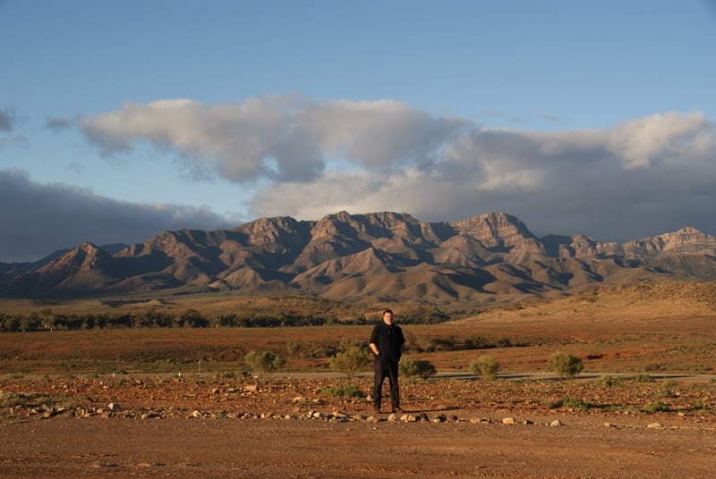
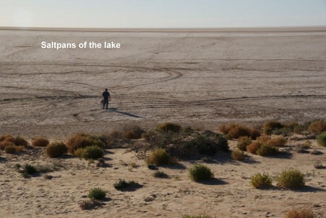
Today is a washing and ‘chilling out’ day here in the middle of the desert! We woke to a frosty morning but a lovely sunrise and clear skies. Absolutely gorgeous out here, despite the barren and desolate countryside. After lunch we decided to take a drive out to Mullorina Station where there is a waterhole and a camp-site. Interesting drive there through some very flat and barren country – a vast ‘nothingness’! We passed through the ‘dog fence’ which is really the vermin fence, which keeps out feral animals like wild dogs and rabbits. Mullorina Station is some 400,000 hectares of land with 4000 cattle on it! The permanent Mullorina Waterhole was like a little oasis in the desert with a scattering of low trees and sandy ground. There were even 2 flushing loos!! Beautiful spot to camp and very peaceful. We noticed there was a sign for a lookout of Lake Eyre north, another 46 kms, so off we headed along an incredibly corrugated and bumpy ride!! When we finally arrived at the lookout, there was a sign saying ‘No Dogs’ after dogs being permitted all the way here until the last 150m to the lookout! We kept madam on her leash and trudged up the hill... only to find the vast flat saltpan of Lake Eyre north and NO water! Apparently, the Cooper Creek has only just started flowing into Lake Eyre North and it will take some time to fill it enough to see it from here and Lake Eyre South is still empty! Rather a disappointment, but still glad to have seen this vast lake and we may return again some time in the future if the water stays in the lake longer this time. We’ve heard it is barely half full but will take till late in the year to fill up with water and for the birds to return to this area again. There is said to be great bird-life up at the Cooper Creek crossing on the Birdsville Track, so we are looking forward to heading up there tomorrow and getting a ride on the old ‘ferry’ that takes you to the other side of the Birdsville Track. This is the first time in 20 years that the Cooper Creek has flowed and cut the Birdsville Track, putting the old ferry back into action again! It can only carry ONE car at a time, so there is a long queue to get across the creek, we’ve heard! There are SO many people up here in the desert, even more so now the school holidays have started!
So, after that trek we headed the 96kms back to our camp site in Marree and arrived just in time for the sunset! Tomorrow will be our last day here so hopefully Rod and his geology Uni mates will get here before we leave for Birdsville. The boys are heading for Alice Springs and passing through Marree, we hope!
Apologies for the layout of the blog at the moment... it is somewhat of a challenge sorting, resizing and editing the photos and remembering to write up the blurb every night so I can just upload it to the blog later!!
Day 10
Wednesday 30th June
After re-fuelling and stocking up at the Marree general store, a quick email to Aimee & Glenn and a text to Rod from the phone box, we departed Marree and headed off along the legendary Birdsville Track towards the Cooper Creek crossing. This track is only suitable for 4WD vehicles – NO 2WD cars, trailers or caravans! The Birdsville Track to Birdsville is some 530 kms through very remote and arid country, crossing the Sturt Stony Desert, the Streczlecki Desert and skirting the Simpson Desert. Much of this country is owned by very large stations, such as Muloorina and Mungarannie along with a few others. Fortunately, some of the track had just been graded, so it was not too bad travelling along it, keeping a reasonable speed around 70-80kmh.
When we arrived at the creek crossing about 3.30pm there was queue of about 5 other cars waiting to get across to the other side of the Birdsville track! Another 2 cars joined the queue behind us. After about 1 ½ hrs, we had our turn to drive onto the old punt and cross the wide creek to the other side. The Cooper Creek is at the moment, about 3m deep and approximately 150m wide at this point – the trip across on the punt takes 10 minutes and is free! Great fun and pretty amazing seeing all that water as it heads into Lake Eyre North and later Lake Eyre South. The lake is now getting close to being 70% full and predictions are that it will reach at least 80-85%.
We got off on the other side of the creek and set off for Mungarannie Hotel and Campsite, some 82kms further north. By now it was well after 5.00pm and the sun was sinking slowly – what a sight! The track on this side is not as good, as the graders have not been able to grade this side of the road, so it was sandy, stony with lots of corrugations, making night driving much more challenging! We arrived at Mungarannie Hotel just after 7.30pm, found a camp-site, set up camp and headed for the very unique and very Australian bar for a few well-deserved drinks before dinner! We were served our drinks by the very charismatic owner, Phil whilst his better half Pam cooked and served meals to other guests in the restaurant. Fabulous atmosphere and a wonderful bar!
Daily Trip Statistics
TOTAL DISTANCE: 248km
MIN. ALTITUDE: minus 40m
MAX. ALTITUDE: 84m
TOTAL TIME: 7hrs 17mins
DRIVING TIME: 3hrs 39mins
STOP TIME: 3hr 38mins
AVERAGE SPEED: 32Kmh
AVERAGE DRIVING SPEED: 64Kmh
MAX. DRIVING SPEED: 95Kmh
Day 11 July 1st
Mungarannie Hotel & Campsite
We had a wonderful night’s sleep, camped right on the edge of the waterhole, sheltering under a large old gnarly gum tree, which we discovered is home to a nest of baby budgerigars in a little hollow of the tree. We awoke to what sounded like being camped inside an aviary, with the sounds of many different birds - waterbirds, parrots, budgerigars etc etc! What an awesome experience! Before breakfast, we decided to have a soak in the large artesian fed ‘hot-tub’ (this was a large 5mx3m tub built with railway sleepers as edging!!) near the waterhole... we stayed in for over an hour it was so wonderful! Even Bekky jumped in with us twice!! The water coming into this pool is around 86°C! Great for filling up the wash bowl to do the dishes! I had to wait awhile before I could get my hands in the water!! By time we got out it was brunch time so I made us a Spanish omelette with left over tomatoes, mushrooms, onions, bacon and potatoes topped with mozzarella cheese!
We took a lovely walk around the waterhole, me getting numerous bird and scenery shots and Bekky taking another swim! The afternoon was spent relaxing and doing these blog notes...AND discovering we have a slow puncture in one of our rear tyres from a large bolt embedded in the centre of the tyre!! Luckily, it’s the worst tyre on the truck but a bloody inconvenience that will need to be fixed, one way or the other! Andrew had to dig out his tyre repair kit and got stuck into fixing the puncture, whilst I cooked up a hearty curry! Fingers crossed the tyre is still good in the morning!
Day 12 July 2nd
Mungarannie to an amazing bush camp by the Diamantina River
Yes! Tyre still good and no sign of any leak, so we headed off up the Birdsville Track, enjoying a variety of landscapes from stony and arid to green and sandy, with even some large patches of water still covering large areas - the Stony Desert on one side and the Streczlecki Desert on the other! Plenty of birdlife and wandering cattle were seen between the high sand-hills, up to 16m high in places! For the most of the time, the track was very reasonable and Andrew was able to sit on 80kmh a lot of the way, stopping now and then to let the ambling Brahman cattle cross the track! Beautiful creatures! Suddenly we came to a dip in the road where the Diamantina River crosses and there was a wide stretch of water tat looked deep but fortunately, a group of bikers and their support vehicle had stopped for lunch at the crossing and assured us it was not very deep and had a stony bottom, not mud! We crossed the river without any problem, the water just reaching over the side-steps of the truck. On the other side we found a lovely spot by the Diamantina River to have our lunch... awesome scenery and a prolific birdlife all around us! We liked it so much, we decided to set up camp there for the night rather than go on to Birdsville. We carefully collected some firewood, taking care not to disturb in critters or take anything that looked like it had a hollow in it that might be home to a rare native animal. We cooked our dinner over the little campfire and listened to the peace of the night, only the distant sound of a lone dingo howling and the sounds of the water running across the road further up. This was a perfect night for stargazing and wow, were they ever bright and in their millions, the Millky Way so dense it looked like a long cloud! Fantastic! How special to camp out here amidst Mother Nature and feel so protected.
Daily Trip Statistics
TOTAL DISTANCE: 233km
MIN. ALTITUDE: 18m
MAX. ALTITUDE: 86m
TOTAL TIME: 3hrs 57mins
DRIVING TIME: 3hrs 11 mins
STOP TIME: 46 mins
AVERAGE SPEED: 57Kmh
AVERAGE DRIVING SPEED: 72Kmh
MAX. DRIVING SPEED: 103Kmh
Day 13 July 3rd
Diamantina camp site to Birdsville
Got up early to witness a stunning sunrise over the river and take yet more photos!! Again, we had a nesting budgerigar in the tree by the tent, plus numerous other birds all around us and again, I heard the far away call of the dingo but even more haunting, the incredibly beautiful calls of the Brolgas on the other side of the river. We could not see them, but we could certainly hear them! Magic! We found a Quandong Tree too and tasted the little berries they call bush plums - very sweet! After breakfast we headed for Birdsville, where we had a great counter lunch and a drink to toast the fact that we'd made it to Birdsville safely!! Met some interesting people there including Norm Harris, a charming and cheeky full blood Aboriginie who tried to tell us he was from Africa! After lunch we continued on for Windorah, coming across numerous emus, red and grey kangaroos and lots of birds. Once again, we bush camped on the side of the road by the Cooper Creek where there were some enormous River Red Gums and again, a prolific birdlife. It is getting colder as we get further south and it was freezing that night!
Daily Trip Statistics
TOTAL DISTANCE: 470km
MIN. ALTITUDE: 110m
MAX. ALTITUDE: 250m
TOTAL TIME: 5hrs 31mins
DRIVING TIME: 4hrs 18mins
STOP TIME: 1hr 14mins
AVERAGE SPEED: 82Kmh
AVERAGE DRIVING SPEED: 104Kmh
MAX. DRIVING SPEED: 138Kmh
Day 14 July 4th
Cooper Creek bush camp to Paroo River bush camp
Another free night of camping on the Paroo River just outside Eulo, Qld. - nice campfire, lots of birds again and another cold night! Getting closer to home and rain heading our way so we are keen to keep moving!
Day 15 July 5th
Paroo River bush camp to Nyngan
Got up early and set off to Nyngan, stopping briefly at Eulo for fuel and to look at Opals and another stop at the Back of Bourke Centre for a rest and re-fuel before setting up camp at Riverside Caravan park in Nyngan. Nice grassy campsite, but very cold again! it was WONDERFUL to have a hot shower after 3 days!! I made us a pot of Chilli Con Carne to warm us up before climbing into the goosedown sleeping bags for the last time this trip!
Daily Trip Statistics
TOTAL DISTANCE: 523km
MIN. ALTITUDE: 97m
MAX. ALTITUDE: 250m
TOTAL TIME: 5hrs 21mins
DRIVING TIME: 4hrs 41mins
STOP TIME: 40mins
AVERAGE SPEED: 97Kmh
AVERAGE DRIVING SPEED: 108Kmh
MAX. DRIVING SPEED: 151Kmh
Day 16 July 6th
Nyngan to Bathurst
A leisurely drive to Bathurst, passing through some quaint little country towns and pretty countryside, the heavy rain clouds still chasing us! We arrived with Andrew's parents early afternoon and had a nice catch up with them, telling them about our fantastic journey to the desert. A few chores need to be done for them before we head off for home in the morning. Very cold here but still and sunny.
Daily Trip Statistics
TOTAL DISTANCE: 365km
MIN. ALTITUDE: 160m
MAX. ALTITUDE: 1000m
TOTAL TIME: 5hrs 15mins
DRIVING TIME: 4hrs 04mins
STOP TIME: 1hr 11mins
AVERAGE SPEED: 68Kmh
AVERAGE DRIVING SPEED: 86Kmh
MAX. DRIVING SPEED: 137Kmh
Day 17 July 7th
Bathurst to Empire Bay - HOME!
After completing a few jobs around the place for Mary and Don, we set off for home just after lunch passing through historic Lithgow and more lovely winter countryside with many big hills, mountains, trees and golden fields. Gorgeous views. We stopped briefly to pick up some fresh fruit and vegetables at a roadside stall in Rouse Hill - we've missed our fresh fruit and veges!! It grew more and more dark as we drove towards home and by the time we reached the freeway, it was raining heavily! However, not so cold anymore!! Just VERY bloody wet!! We arrived home about 4.30pm, by which time it was an absolute torrential downpour! Heaters on, kettle on and the first load of washing popped in the washer! Phew! We made it and what a wonderful trip it was, despite the cold!! Over the almost 5000 kms travelled, we met so many interesting people, saw SO much and had just the one little puncture at the Mungarannie Camp Site! We learnt a lot about camping, the outback, people... life, in general!! We'd recommend it to anyone with a sense of adventure and a love of the Aussie outback and history, but DO remember to go well prepared and with an open mind!!